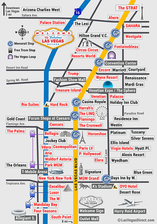
Use our interactive Vegas maps to find the best location for your hotel stay on the main Las Vegas Strip and Downtown Vegas. The maps include major shows and attractions , monorail stops, and free tram stop locations along the Vegas Strip. You can also visit the properties listed by clicking on hotels to shop and compare the best rates. Our walking distance tool and printable maps can help you get around during your Vegas trip.
Vegas Strip Map Click on Hotels for Best Rates and Info.
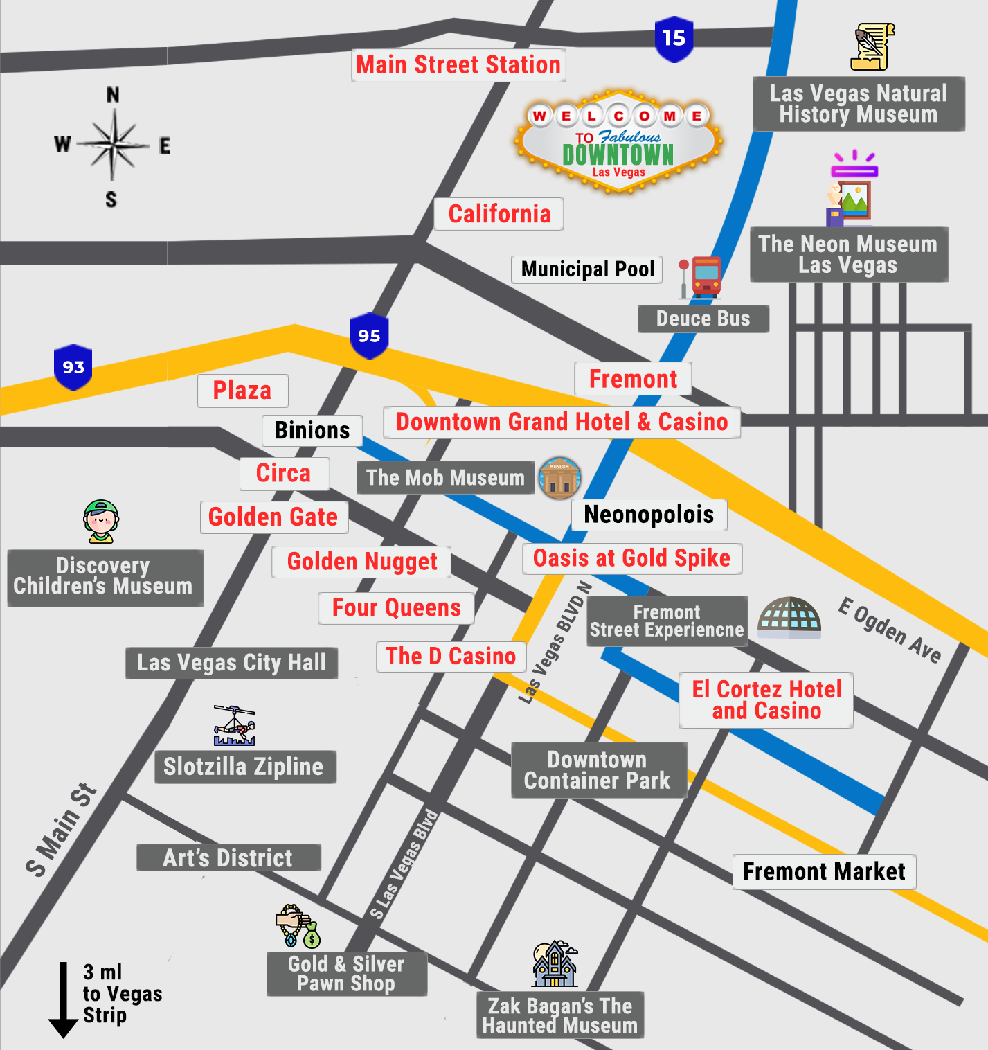
Downtown Las Vegas Hotel Map Downtown Vegas is located about 3 Miles North of the Strip. It used to be the place for budget “Classic Vegas” hotels, but is now a lot more popular and trending with many newer hotels and attractions .
Click on Hotels and Attractions for Best Rates and Info.
Vegas Strip Hotel Walking Times
The Las Vegas strip is about 4.2 miles (6.8 km) long. You can walk it in about 90 minutes (45 minutes if you walk fast), but plan on it taking 2+ hours to give you time to enjoy the amazing sights. Like all deserts, Vegas weather can get very hot during the summer, so wear sunscreen and bring water. Be prepared for chilly temps while walking outside during the fall and winter.
Use our walking distance tool below for approximate walking times between hotels.
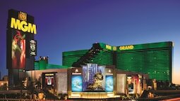
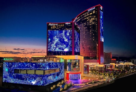
Airport (Harry Reid) ARIA Resort & Casino Alexis Park All Suite Resort Bellagio Best Western Hoover Dam Hotel Caesars Palace - Resort & Casino California Hotel and Casino Cancun Resort by Diamond Resorts Cannery Hotel & Casino Circa Resort & Casino - Adults Only Circus Circus Hotel, Casino & Theme Park Club De Soleil All-Suite Resort Courtyard by Marriott Las Vegas Convention Center Courtyard by Marriott Las Vegas Henderson/Green Valley Courtyard by Marriott Las Vegas South Desert Rose Resort DoubleTree by Hilton Las Vegas Airport DoubleTree by Hilton Las Vegas East Flamingo Downtown Grand Las Vegas Durango Casino & Resort El Cortez Hotel and Casino - Adults Only Elara by Hilton Grand Vacations - Center Strip Element Las Vegas Summerlin Encore at Wynn Las Vegas Excalibur Hotel & Casino Flamingo Las Vegas - Hotel & Casino Four Queens Hotel and Casino Four Seasons Hotel Las Vegas Fremont Hotel & Casino Gold Coast Hotel and Casino Golden Nugget Las Vegas Hotel & Casino Grandview at Las Vegas Green Valley Ranch Resort and Spa Hampton Inn & Suites Las Vegas South Harrahs Las Vegas Hilton Grand Vacations at The Flamingo Hilton Grand Vacations on the Las Vegas Strip Holiday Inn Club Vacations at Desert Club Resort Holiday Inn Express Las Vegas-Nellis Homewood Suites by Hilton Henderson South Las Vegas Homewood Suites by Hilton Las Vegas Airport Hoover Dam Lodge Horseshoe (Ballys) Las Vegas Hyatt Place Las Vegas JW Marriott Las Vegas Resort & Spa Jet Luxury at the Vdara Condo Hotel La Quinta Inn by Wyndham Las Vegas Nellis Las Vegas Marriott Luxor Hotel and Casino Luxury Suites International At The Signature MGM Grand Hotel & Casino Mandalay Bay Resort And Casino Marriotts Grand Chateau New York-New York Hotel & Casino OYO Hotel and Casino Las Vegas Oasis at Gold Spike - Adults Only Palace Station Hotel and Casino Palms Place Hotel and Spa at the Palms Las Vegas Paris Las Vegas Resort & Casino Park MGM Las Vegas Planet Hollywood Resort & Casino Plaza Hotel and Casino - Las Vegas Polo Towers by Diamond Resorts Raintree At Polo Towers, Las Vegas Renaissance Las Vegas Hotel Residence Inn By Marriott Las Vegas/Green Valley Residence Inn Las Vegas Convention Center by Marriott Residence Inn Las Vegas South/Henderson Residence Inn by Marriott Las Vegas Hughes Center Residence Inn by Marriott Las Vegas South Resorts World Las Vegas Rio All-Suite Hotel & Casino SAHARA Las Vegas Santa Fe Station Hotel & Casino Secret Suites at Vdara Shalimar Hotel of Las Vegas Signature Affordable Luxury Sonesta Select Las Vegas South Point Hotel, Casino, and Spa SpringHill Suites by Marriott Las Vegas Convention Center SpringHill Suites by Marriott Las Vegas Henderson SpringHill Suites by Marriott Las Vegas North Speedway Staybridge Suites Las Vegas StripViewSuites at Signature Suncoast Hotel and Casino Sunset Station Hotel & Casino TI - Treasure Island Hotel and Casino Tahiti All-Suite Resort Tahiti Village Resort & Spa The Cliffs at Peace Canyon The Cosmopolitan Of Las Vegas The D Las Vegas The English Hotel Las Vegas - Adults Only The LINQ Hotel + Experience The Lexi Las Vegas - Adults Only The M Resort Spa Casino The Orleans Hotel & Casino The Palazzo at The Venetian The Palms Casino Resort The Platinum Hotel The Reserve at Park MGM The SKYLOFTS at MGM Grand The Signature at MGM Grand The Strat Hotel, Casino and Skypod The Venetian Resort Las Vegas The Westin Lake Las Vegas Resort & Spa Tuscany Suites & Casino Virgin Hotels Las Vegas, Curio Collection W Las Vegas (Delano Las Vegas at Mandalay Bay) Waldorf Astoria Las Vegas Westgate Las Vegas Resort & Casino Wynn Las Vegas
distance to
Airport (Harry Reid) ARIA Resort & Casino Alexis Park All Suite Resort Bellagio Best Western Hoover Dam Hotel Caesars Palace - Resort & Casino California Hotel and Casino Cancun Resort by Diamond Resorts Cannery Hotel & Casino Circa Resort & Casino - Adults Only Circus Circus Hotel, Casino & Theme Park Club De Soleil All-Suite Resort Courtyard by Marriott Las Vegas Convention Center Courtyard by Marriott Las Vegas Henderson/Green Valley Courtyard by Marriott Las Vegas South Desert Rose Resort DoubleTree by Hilton Las Vegas Airport DoubleTree by Hilton Las Vegas East Flamingo Downtown Grand Las Vegas Durango Casino & Resort El Cortez Hotel and Casino - Adults Only Elara by Hilton Grand Vacations - Center Strip Element Las Vegas Summerlin Encore at Wynn Las Vegas Excalibur Hotel & Casino Flamingo Las Vegas - Hotel & Casino Four Queens Hotel and Casino Four Seasons Hotel Las Vegas Fremont Hotel & Casino Gold Coast Hotel and Casino Golden Nugget Las Vegas Hotel & Casino Grandview at Las Vegas Green Valley Ranch Resort and Spa Hampton Inn & Suites Las Vegas South Harrahs Las Vegas Hilton Grand Vacations at The Flamingo Hilton Grand Vacations on the Las Vegas Strip Holiday Inn Club Vacations at Desert Club Resort Holiday Inn Express Las Vegas-Nellis Homewood Suites by Hilton Henderson South Las Vegas Homewood Suites by Hilton Las Vegas Airport Hoover Dam Lodge Horseshoe (Ballys) Las Vegas Hyatt Place Las Vegas JW Marriott Las Vegas Resort & Spa Jet Luxury at the Vdara Condo Hotel La Quinta Inn by Wyndham Las Vegas Nellis Las Vegas Marriott Luxor Hotel and Casino Luxury Suites International At The Signature MGM Grand Hotel & Casino Mandalay Bay Resort And Casino Marriotts Grand Chateau New York-New York Hotel & Casino OYO Hotel and Casino Las Vegas Oasis at Gold Spike - Adults Only Palace Station Hotel and Casino Palms Place Hotel and Spa at the Palms Las Vegas Paris Las Vegas Resort & Casino Park MGM Las Vegas Planet Hollywood Resort & Casino Plaza Hotel and Casino - Las Vegas Polo Towers by Diamond Resorts Raintree At Polo Towers, Las Vegas Renaissance Las Vegas Hotel Residence Inn By Marriott Las Vegas/Green Valley Residence Inn Las Vegas Convention Center by Marriott Residence Inn Las Vegas South/Henderson Residence Inn by Marriott Las Vegas Hughes Center Residence Inn by Marriott Las Vegas South Resorts World Las Vegas Rio All-Suite Hotel & Casino SAHARA Las Vegas Santa Fe Station Hotel & Casino Secret Suites at Vdara Shalimar Hotel of Las Vegas Signature Affordable Luxury Sonesta Select Las Vegas South Point Hotel, Casino, and Spa SpringHill Suites by Marriott Las Vegas Convention Center SpringHill Suites by Marriott Las Vegas Henderson SpringHill Suites by Marriott Las Vegas North Speedway Staybridge Suites Las Vegas StripViewSuites at Signature Suncoast Hotel and Casino Sunset Station Hotel & Casino TI - Treasure Island Hotel and Casino Tahiti All-Suite Resort Tahiti Village Resort & Spa The Cliffs at Peace Canyon The Cosmopolitan Of Las Vegas The D Las Vegas The English Hotel Las Vegas - Adults Only The LINQ Hotel + Experience The Lexi Las Vegas - Adults Only The M Resort Spa Casino The Orleans Hotel & Casino The Palazzo at The Venetian The Palms Casino Resort The Platinum Hotel The Reserve at Park MGM The SKYLOFTS at MGM Grand The Signature at MGM Grand The Strat Hotel, Casino and Skypod The Venetian Resort Las Vegas The Westin Lake Las Vegas Resort & Spa Tuscany Suites & Casino Virgin Hotels Las Vegas, Curio Collection W Las Vegas (Delano Las Vegas at Mandalay Bay) Waldorf Astoria Las Vegas Westgate Las Vegas Resort & Casino Wynn Las Vegas
Select hotels for approximate distance

")